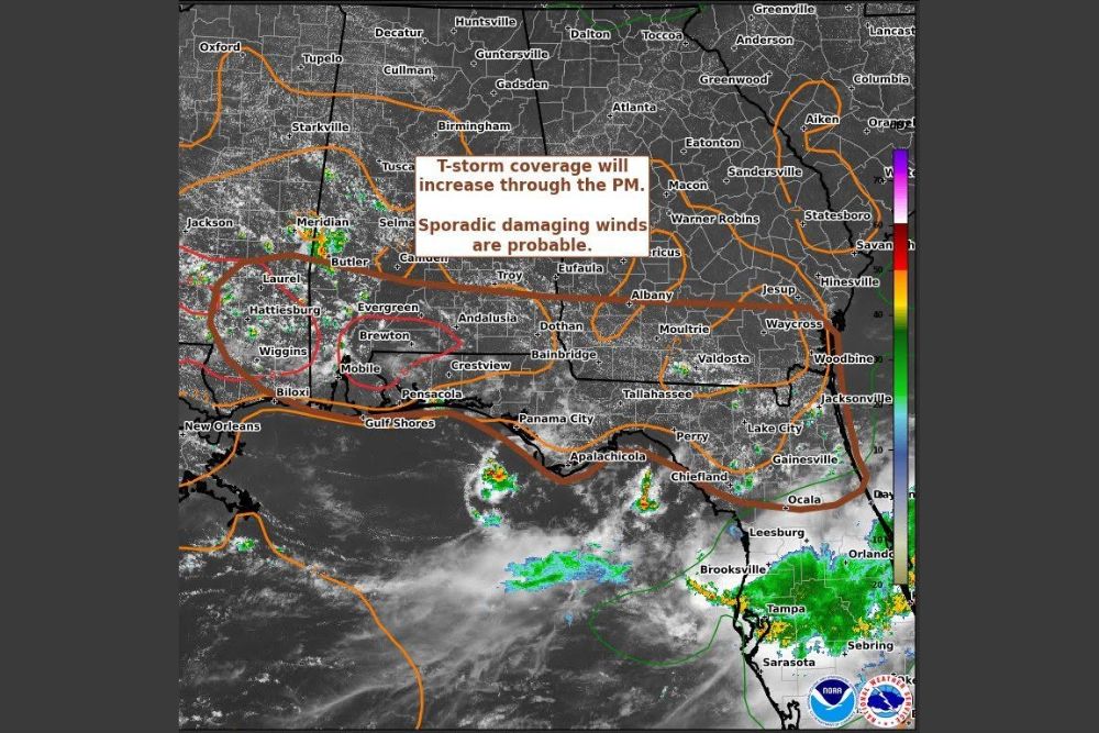
NORTH FLORIDA AND GULF COAST — Isolated storms are expected to pop through the afternoon into the evening across north Florida and the upper eastern Gulf region, according to a Storm Prediction Center Mesoscale Discussion valid until 3:30 p.m. Thunderstorm coverage will increase through the afternoon, with sporadic damaging winds considered probable across the highlighted area stretching from Mobile and Pensacola through Tallahassee, Gainesville, and Ocala.
Thunderstorm Coverage Expected to Increase Through the Afternoon
The Storm Prediction Center says thunderstorm coverage will increase through the afternoon hours across the highlighted zone, which spans a wide area from southern Alabama and Mississippi into the Florida Panhandle and north Florida.
Communities including Mobile, Pensacola, Panama City, and Tallahassee fall within this developing coverage area, where isolated storms are expected to become more numerous as daytime heating continues building instability.
Sporadic Damaging Winds Considered Probable
Forecasters specifically flag sporadic damaging winds as probable with today’s storms, identifying wind gusts up to 60 mph as the most probable peak intensity associated with the strongest cells expected to develop.
This wind threat represents the primary hazard for the region today, with communities from Gulf Shores through Valdosta and Waycross at risk for sudden, gusty wind damage as isolated storms track through the area.
Severe Weather Watch Considered Unlikely Despite Concern
Despite the concerning potential for sporadic damaging winds, the Storm Prediction Center rates the probability of an actual severe thunderstorm watch being issued at only 20 percent for this Mesoscale Discussion.
This reflects a scenario where forecasters are watching genuine wind potential closely without yet having enough confidence in organized, widespread severe storm development to warrant a formal watch across the region.
Satellite Imagery Shows Developing Activity Near the Coast
Satellite imagery included with the discussion shows areas of developing convection near the coast, including activity visible offshore and approaching areas around Panama City, Apalachicola, and the Big Bend region of Florida.
This coastal development aligns with the broader outlook for increasing afternoon and evening thunderstorm coverage, as sea breeze interactions along the Gulf often help trigger and organize storms during summer afternoons.
Residents Urged to Stay Aware Through the Evening Hours
Given the probable sporadic damaging wind threat, residents across north Florida and the upper Gulf Coast, including Tallahassee, Gainesville, and Valdosta, are encouraged to stay weather aware through the afternoon and evening.
Isolated but potentially strong storms could develop with little advance notice, making it worthwhile for residents throughout the highlighted zone to monitor conditions closely as Thursday’s storm activity continues to build.